.png)

OUR SERVICES
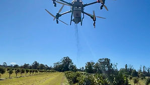
Precision Agricultural Drone Services Across Northern Rivers. At Terra Agri Tech, we help farmers spray smarter, cover more ground faster, and reduce crop damage using advanced agricultural drone technology.Our drone services are designed for real farming conditions — allowing precise application across wet paddocks, steep terrain, orchards, and hard-to-reach areas where traditional machinery struggles.Using GPS-guided agricultural drones, we provide efficient spraying, spreading, mapping, and precision farming solutions that help improve productivity while reducing chemical waste, soil compaction, and operational downtime

SPRAYING
Fast, Precise Crop Spraying Without Soil Damage
Our drone spraying services provide accurate application of:
-
Herbicides
-
Fungicides
-
Pesticides
-
Foliar nutrients
Unlike traditional boom spraying, drone application eliminates wheel tracks and soil compaction while improving precision and reducing overspray.
Drone spraying is ideal for:
-
Wet paddocks
-
Steep terrain
-
Orchards & vineyards
-
Difficult-to-access areas
-
Spot spraying & targeted weed control
Whether you require targeted weed control or broadacre applications, Terra Agri Tech delivers efficient, reliable results tailored to your property.
SPREADING
Accurate Fertiliser & Seed Distribution
Our agricultural drones provide precise spreading of:
-
Fertiliser
-
Granules
-
Seed
-
Cover crops
-
Soil amendments
Using variable-rate technology and advanced GPS guidance, we ensure even coverage while minimising overlap and product waste.
Drone spreading is perfect for:
-
Steep country
-
Wet paddocks
-
Sensitive soil areas
-
Remote or uneven terrain
Our flexible spreading solutions help improve efficiency while protecting paddocks and soil health.

MAPPING
Smarter Farming Through Precision Mapping
Using high-resolution drone imagery and advanced aerial mapping technology, Terra Agri Tech helps farmers identify issues early and make more informed farm management decisions.
Our mapping services provide insights into:
-
Crop health
-
Plant stress
-
Drainage issues
-
Soil variability
-
Field performance
We deliver actionable aerial data to help optimise:
-
Input use
-
Irrigation planning
-
Yield potential
-
Farm efficiency
Drone mapping gives you a clearer view of your land — helping improve productivity and profitability.